Land use change
Cerrado in Portuguese translates as ‘closed’ or ‘dense, and until the 1970s the Cerrado region was considered to be rough, inaccessible terrain. Before the mid-1970s, the Cerrado was
characterised by a low population density. Cattle ranching and some subsistence agriculture were concentrated in the most fertile soils along the rivers (Ayarza et al., 2007; Jepson et al.,
2010). The transfer of the Brazilian capital to Brasília in the 1960s and the construction of roads and railways contributed significantly to the region’s development. During the 1970s,
occupation of this area was encouraged by the Brazilian government through the PROÀLCOOL Programme, POLOCENTRO, and the PRODECER Development Projects (Pires 2000; Soccol et al., 2005; Ayarza et
al., 2007; Ferreira and de Deus 2011; Pereira et al., 2012). These programs led to an expanding deforestation and occupation of the Cerrado (Jepson et al., 2010; Grecchi et al., 2013) to use it
both for grazing and crop production (Marris 2005).

In the 1990s, the amelioration of subsoil acidity led to a release of phosphate and sulphate from Al/Fe-hydroxides, thus increasing soil fertility (Joris et al., 2012). The implementation of
adapted crop rotation and intercropping with legumes for fixing atmospheric nitrogen increased progressively (Lopes 1996; Mattsson et al., 2000) The Brazilian Agricultural Research Corporation
(EMBRAPA: Empresa Brasileira de Pesquisa Agropecuária) led the breeding of tropical crops (see Lopes et al., 2012). They improved tolerance against dry climate and acid soil conditions (FAS,
Foreign Agricultural Service, USDA 2003) and significantly reduced the growing period. For example, they cut eight to twelve weeks off the usual life cycle of soybeans. This now allows double or
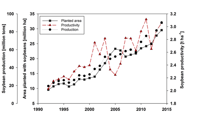
even triple cropping per year, with the potential to increase soybean yield from 3 t/ha to 5 t/ha (FAS-USDA, 2003). Brazil’s planted area for soybeans increased to 30 Mha in 2013 with
simultaneously increased productivity which resulted in a production of 90 million tons of soybeans per year (Figure). Genetically modified crops are also widely used. In 2012, 71% of Brazil’s
total soybean growth of was genetically modified (Marinho et al., 2012) making Brazil the second-largest producer of genetically modified crops (Melo et al., 2010). The Cerrado is now among the
world's top regions for the production of soybeans (IBGE 2013, Smaling et al., 2008; Batlle-Bayer et al., 2010).
For the years 2008-2010, deforestation rates were more than twice as high as in the Amazon basin (Sawyer 2008; Lambin et al., 2013). Only 2% of the biodiversity hotspot regions are preserved in
strictly protected areas (after World Conservation Union Categories I to III) (Myers et al., 2000; Jepson 2005; Klink and Machado 2005; Silva et al., 2006). The conservation effort in the Cerrado
is always secondary to that in the Amazon (Barreto et al., 2013), and deforestation is easier realisable (Mittermeier et al., 1999; Klink and Machado 2005; Sparovek et al., 2010) as the new
Forest Code (Government of Brazil 2012, Law No. 12.727/2012) implies reductions of legal requirements for both permanent protection areas (PPA) and legal reserve areas (LRA). Important changes
include the exclusion of the PPA-class ‘‘hill tops’’ and the reduction of buffer strips for small rivers. On private land in the Cerrado regions outside the Legal Amazon Region a reduction of LRA
to 20% is allowed, as opposed to only 35% of allowed clear-cutting after the legislation until 2012 (Sparovek et al. 2012; Stickler et al., 2013). In the Amazon Basin, in contrast, 6% of the area
is strictly protected, and an additional 17.7% is preserved as indigenous lands (Klink and Machado 2005).
The rapid agricultural development is being enhanced by infrastructure developments in the formerly remote areas (Rada 2013). The construction of the transregional BR-163 highway from Cuiabá,
capital of Mato Grosso in the western Cerrado, to the most important industrial harbour of the Amazonas River in Santarem, for instance, opens up an export corridor for cash crops to
international markets (Fearnside 2007)
Future land use
Projections of future land use show that the trend towards intensive agricultural use is likely to continue for the entire Cerrado region (Janssen and Rutz 2011). Soares-Filho et al., (2004)
developed a land-cover change model estimating that until 2036 the total forested area in the region will decline by 35 % for the scenario with high population growth and by 13-16 % for
governance scenarios. Projecting deforestation trends until 2050, Ferreira et al. (2012) estimate an increase in deforested areas of 13.5% which is 40,000 km² per decade mainly in the states
Bahia, Maranhão, Mato Grosso and Tocantins. Moreover, Soares-Filho et al. (2014) found that the revision of the Brazilian Forest Act (Sparovek et al., 2012) will allow additional deforestation in
the Cerrado. As much as 600,000 km² unprotected vegetation could be converted according to the current legislation (reviewed by Lambin et al., 2013).